
Often, a sudden downpour means the difference between a normal commute and a washed-out road, between healthy crops and devastating losses. It can mean a quiet night at home or a frantic scramble for safety as flash floods turn streets into rivers. For millions of people across the contiguous United States, hourly precipitation forecasts are not just curiosities; they are critical tools for making real-time decisions that protect lives and livelihoods.
The trouble is, predicting exactly how much rain will fall, where, and when—especially minute by minute, hour by hour—has always been a profound challenge for meteorologists. Traditional weather models often tell us if it will rain, but they struggle to give us the precise details: the exact amount, the exact probability, and the specific distribution across a local area. This uncertainty makes it hard for emergency services, farmers, and even city planners to prepare for highly localized, intense events.
Now, a new approach promises to cut through that uncertainty. A scientific preprint appearing on arXiv describes a method that delivers spatially detailed, highly reliable forecasts of hourly rainfall. The research, led by Thomas M Hamill, introduces what scientists call an "Attention Residual U-Net to power a new form of Probabilistic Quantitative Precipitation Forecasting (PQPF).
This isn't just another weather forecast. This method shifts from guessing if rain will fall to predicting the likelihood of no rain at all, and for positive rainfall, it predicts the range of intensities we might see. This means we get a better picture of the odds for different rainfall amounts. Imagine not just a 50% chance of rain, but a 20% chance of heavy rain, a 30% chance of light rain, and a 50% chance of no rain at all. This level of detail makes a world of difference for planning.
To achieve this, the neural network learns from a vast trove of information. It processes hourly precipitation data from high-resolution atmospheric models, like The Weather Company's GRAF model, alongside terrain data and humidity levels from NOAA's GFS model. The network then compares its predictions against real-world observations: high-quality radar data from NOAA’s Multi-Radar, Multi-Sensor (MRMS) system, which is corrected by physical rain gauges on the ground and carefully checked for accuracy.
The method uses advanced statistical techniques that model positive precipitation with what are called Gamma distributions, allowing it to capture the wide variability of rainfall, from a light drizzle to a heavy downpour. It learns to fine-tune its accuracy by minimizing a measure called negative log-likelihood, which helps it make its predicted probabilities match observed reality. This rigor in quantifying probabilities and evaluating data quality mirrors the careful work done in fields like gravitational-wave astronomy, where scientists must tease out faint signals from noisy data and precisely quantify the chance of a real event versus random fluctuations.
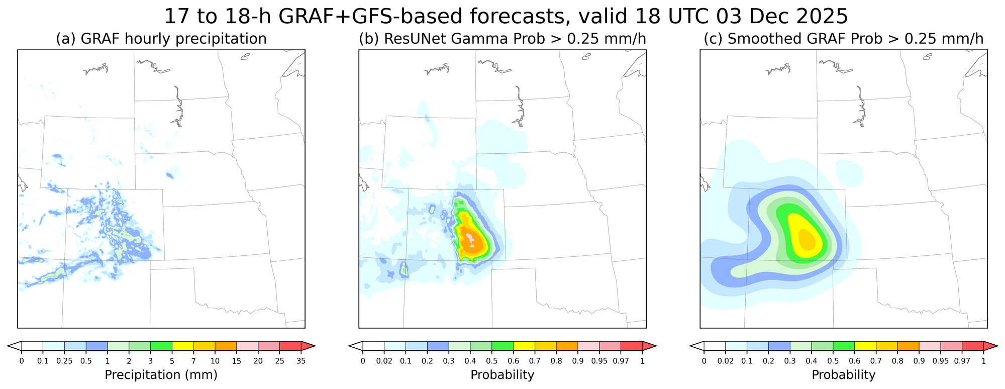
The consequence of this painstaking process is a forecasting system that is especially skilled in regions with varied terrain, like mountains and valleys, where precipitation patterns can be notoriously complex and localized. The forecast isn't just an overall number; it's a map of probabilities that is specific down to individual grid points. Running this complex calculation for the entire contiguous United States is handled efficiently in a single processing step, with techniques to ensure complete and accurate coverage across all edges of the forecast area.
This advancement means that emergency managers could receive more specific warnings for potential flash floods in a particular valley, giving them precious extra time to issue evacuation orders. Farmers could make more informed decisions about when to plant or harvest, knowing the precise probability of various rainfall amounts in the coming hours. Construction crews could better schedule work, minimizing delays due to unexpected heavy rain.
The goal isn't to give a single, perfect answer that will always be right. No forecast can do that. The goal is to provide reliable, calibrated probabilities. This means that if the forecast says there’s a 30% chance of an inch of rain, then over many such forecasts, that specific amount of rain should indeed occur about 30% of the time. This trustworthy quantification of uncertainty is what allows decision-makers to weigh risks and plan accordingly, something simpler methods often fail to deliver.
The next step is for this specific, reliable approach to transition from research into widespread operational use. Integrating such refined probabilistic forecasting into public weather alerts and decision-support systems will empower communities to better navigate the very real and immediate challenges posed by unpredictable weather, helping millions better prepare for whatever the sky brings next. ◆
Sourced from: "High-resolution Calibrated Probabilistic Hourly Precipitation from a Deterministic Forecast" by Thomas M Hamill